I got my first taste of hiking in South Korea in 2016 at Jaunbong Peak, Dobongsan. The experience was so memorable I vowed to return, setting my sights on Baegundae Peak, which finally materialised on 11 September 2023.
Highest point of Seoul

At 836m (2,744ft), Baegundae Peak is 280m higher than the Lotte World Tower, with breathtaking views of Seoul in all directions.
Besides being the most popular summit among hikers from various access points, there are multiple routes of varying distance and difficulty levels to choose from. Justifying a second / third visit is extremely easy, as even a repeat visit can be a whole new experience, depending on the season!
I chose to visit on a Monday to avoid the weekend day hikers. Below is a shot of how crowded it gets on Sunday at the final 300m, courtesy of JackandJill.

9.30am On arrival at Bukhansan Fortress, I made sure to stop by the Ranger office to pick up a trail map and have it marked with my intended route for easy reference.
Though sorely tempted, I decided against doing the Bukhansan Fortress – UI Station trans trail, opting instead for a loop trail from Bukhansan Fortress (west entrance), as I wanted to shop for hike gear, after.
There are more hike shops and choices here, compared to UI Station, which has just the one shop.
9.40am I decided on the valley trail that meanders alongside a stream, an easy scenic walk with gorgeous mountain views and granite peaks.

Though the water level was low, the Chinese minnow fish (bottom left picture) appeared to be thriving, regardless.


9.55 am The initial dirt track was mostly flat, taking me past a newish temple with ‘human-like’ rock cairns. Five minutes later, a boardwalk followed by a flight of steps led me out of the valley and into the forest.
Thereafter, the forested trail turned stony and starts climbing in earnest.


10.27 am Approaching a split junction, I asked for directions and was ‘adopted’ by a Chinese Korean couple who invited me to join them.
I happily followed them up the direct (difficult) route characterised by steep twists and turns as it wound upwards.
A few minutes later, we came to a charming archway pointing the way to a Buddhist temple. Giving the temple a miss, we continued right, up a seemingly giant rock staircase with endless steps.


The next 90 minutes was an unrelenting incline of stone steps, rock slopes and sheer granite. For better safety, sections of the path had handrails bolted down securely to aid hikers going up/down.


11.26am As the terrain became more rugged, I soon found myself scrambling up rockpiles and squeezing through granite boulders.


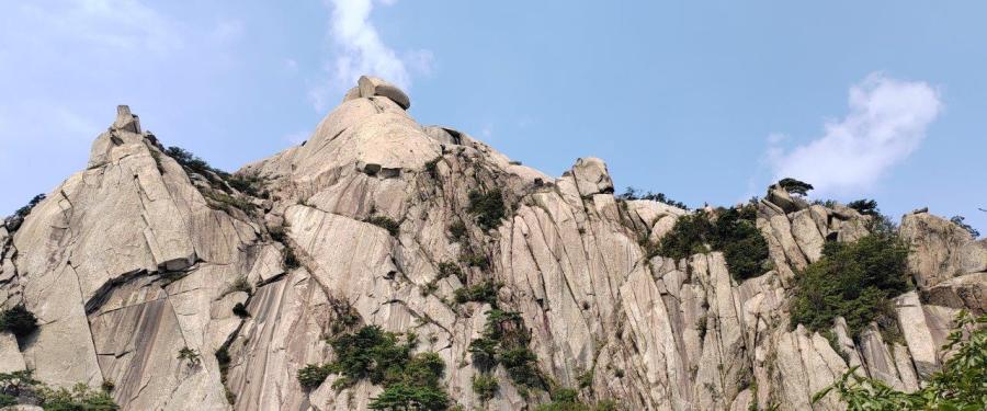
11.44am As I zig zag up the rockiest section, I had my first glimpse of Baegundae Peak during a break in foliage.


Five minutes later, I arrived at the intersection where the Baegundae Peak easy (gradual) course meets the difficult (steep direct) course.
11.51 am After a most enjoyable 1.5 hours my new found friends and I parted ways.
They were excellent guides, leaving me detailed directions to connect to Bukhansanseong (Fortress) easy course for my return journey.


11.55am A long flight of stairs brought me to ‘Wie-mun’ Gate ever so quickly.
Formerly known as Baek-Wun Bong-‘am-mun Gate, it is one of eight secret gates built in 1711, used to transport weapons, munitions and injured soldiers during emergencies.
I passed through the unassuming gate and immediately tuned left, walking along the fortress wall.
Nb. Those coming from Bukhansan Ui Subway Station will reach this gate from Harooje Pass, turning right immediately without going through the gate.

11.58 am I paused at the foot of a massive rockface.

The moment I had been anticipating was finally here. Known as the toughest part, my gaze travelled a long way up, following the line of hikers.
Judging by how carefully the hikers were making their way down the smooth surface, I figured the descent would be equally, if not more challenging.


I started my final ascent, alternating between steps hewn into the rocks and hauling myself up along the anchored handrail.

While my shoes found traction on the smooth surface, the presence of the railings is very comforting. This next section has a proper stairway wide enough for 2-way traffic.
The steps are lined with rubber treads to make it less slippery, especially in winter.

12.03pm At one point when I looked up, hikers ahead of me appeared to be walking cliffside, on the edge of nothingness. Scary!

The big reveal is at the top of the stairs.
The barely 1-foot ledge is mostly level, while cable ropes serve as a cursory barrier against the sheer drop.

12.12 pm After rounding numerous corners, the peak was finally in sight. Already feeling the cardio burn from the quick elevation gain which did not let up, the final approach must have been a 55° slope (at least!). I scrambled, using the metal rods as leverage, subjecting my arm muscles to a solid workout.


12.15 pm The elation of reaching the 360° panoramic top is beyond description. A Japanese tourist helped me take the obligatory shots and I happily returned the favour. Though not crowded (less than 10 people), the peak is a small area, so we moved on to make room for others.


After summiting Baegundae, there are many chill spots to hang out at – from a huge slab of rock just below to nearby boulders to the north and east.


We made our way to the outcrop for a bird’s eye view of Seoul city, soaking in the sprawling mass of buildings and surrounding mountain ranges. Of course, we took more pictures before relaxing over lunch.

12.56pm My descent was more leisurely, with frequent photo stops.
By now the traffic on this last stretch had definitely picked-up.


1.01 pm On the way up, I did not notice the fortress wall (at left) or the view behind me. This time I made sure to be in the moment and savour it.

Below is a picture of hikers at the same fortress wall taken 15 minutes later (from below), shortly after I started on the Bukhansanseong easy course.

1.10 pm From Wie-mun gate, I backtracked to the intersection and followed directional signs to Bukhansanseong. Along the way, I couldn’t resist looking back at Baegundae Peak, reliving unique moments of the awesome climb.

Still basking in the euphoria of standing on the highest point of Seoul, my emotions ranged from immense satisfaction to delirious joy.
1.16 pm The gradual route weaves along the side of the mountain, offering 180° views of Seoul on my right.

Initially, the undulating the trail dipped and climbed over a mixed terrain of dirt trails, stone steps and wooden stairways.


1.25 pm Feeling good, I took the opportunity to practice my limited Korean, cheerfully greeting hikers ‘annyeonghaseyo‘ (Hello) and ‘gamsahamnida‘ (thank you) as we passed.


1.40 pm About 1.2km from Wie-Mun gate, I encountered another section of the fortress wall.

The Yong-am-mun ‘secret’ Gate has wall ramparts extending to the right and left.
The trail on the other side of the gate leads to Doseonsa Temple, finishing at Bukhansan Ui.


From this point onwards the trail descends steadily. I picked up the pace, continuing along the rocky steps that soon gave way to a forested dirt path.
1.46 pm Getting to Bukhansan Shelter was the easy part as it was well sign-posted. Locating the trail to Bukhansanseong was more complicated as it is behind the hut, on the other side.


I dutifully circled the shelter and found a trail curving to the right.
Just then, a hiker came along from the opposite direction and confirmed that I was on the right track.
2.02 pm After passing Taegosa temple, the trail became less discernable. The dry creek bed can easily be mistaken for a trail. I stoically found my own downhill path until the trail became obvious again.


2.21 pm As the path widened, evolving from gravel to stone pavers, I once again confirmed the route with a passing hiker, who told me that I had 3 km to go.


Bukhansanseong Fortress
The Bukhansanseong Fortress is an example of Korean castle architecture and a unique structure from the Joseon period built during the year 1711. It served as a royal retreat with 120 rooms, 16 gates - 6 great gates, 8 secret gates, 2 water gates, and 143 seong-rang (sentry post).  It stretches a distance of 7.89 miles (12.7 km) covering an area of 16 square miles (6.2 sq km).
Source: Global Alliance of National Parks

2.30 pm Jung-seong-mun (Great gate) was built in 1714 to protect the inner fortress and essential facilities, such as Haeng-gung-ji (temporary palace) and Sang-Chang-ji (munitions storage).
This scenic area has lush foliage and delightful fungi.


Not long after, I reached a huge intersection with directional signs pointing everywhere but Bukhansanseong. Notable structures here include Borisa Temple and Bukhandong History Museum, alongside amenities such as drinks vending machines, rest area and public toilets.
Choosing to stay on the straightest route, my hunch paid off when I came upon a paved road wide enough for authorised vehicular access.
I was officially on the ‘main road’.
2.48 pm Muryansa Temple is beautifully well maintained.


2.54 pm Dae-seo-mun (Great West Gate) is the main gate of Bukhansanseong, sitting at the lowest elevation of the sixteen fortress gates located in the park.

It also served as the main access point for villagers living within the fortifications during the Joseon era.
3.11 pm Back at the Bukhansanseong Park Information Center, I rewarded myself with a cold drink from the vending machine before indulging in some retail therapy at the many outdoor shops I passed by that morning.
Getting there – The Bukhansanseong Park Information Centre
- Get off at Gupabal Station (Head to Exit 1, do a U-turn at street level. Bus-stop is 20m).
- Take the metro (subway) – Orange line 3 (towards Daehwa).
- Get on bus 704/ 34 /8772
- Get off at Bukhansanseong Fortress stop, follow the Bukhansan National Park sign to the entrance

Direction : Clockwise
Date : 11 Sept 2023
Duration : 5:41 hours
Distance : 8.6 km

Bukhansan National Park lies at the northern boundary of Seoul and is one of the most popular hiking destination in Seoul, with its abundance of granite peaks, nature trails, gorges, trickling streams and 3,100 species of plants & animals.

The park is also known as Samgaksan (Three-horned Mountain) due to its three highest peaks - Baegundae (836m), Insubong (810m) and Mangyeongdae (787m).

Bukhansan is home to many historical and cultural sites including the 2000-year old Bukhansanseong Fortress, Buddhist temples and hermitages. The park is easily accessible via public transport (subway/ bus) or private car, from any of it many entrances.

Opening Hours :
March to November 04:00 - 17:00
December to February 04:00 -16:00
Free Admission
6D/5N Seoul Itinerary
8/9/2023- N Seoul Tower
9/9/2023 – Free Walking tours in Seoul – Hanok Buckhon Village
10/9/2023 – Seoul walking tours – Cheonggyecheon (Stream) & Seoul Old City Wall (Naksan Park)
11/9/2023 – Baegundae Peak, Bukhansan
12/9/2023 – Day Trip : Gangchon Rail Bike, Nami Island, Garden of Morning Calm

Very nice report
LikeLiked by 1 person
Thank you for this wonderful report. May I use to photos of it for an article about hiking in South Korea? Please contact me on my email adress, thank you very much!
Nicolas
LikeLiked by 1 person
Hello Nicolas, apologies for the belated response. I just completed a 10-day Peaks of the Balkans (POB) hike.
Sorry, I can’t find your email and yes, you may use my photos on Begundae, South Korea. Appreciate if you can ‘Credit Image to Phoenix Trails” and include a hyperlink to phoenixtrails.home.blog
Tq for reading my blog and glad that you found it helpful. Cheers!
LikeLike
hi, is this trail good for newcomers or slow pacers? since i saw a lot of your posts are hiking gunungs when i’m a bukit kind of person 😂 i’m going to seoul end of this month so thinking of i should try this trail.. please advise ya 😃
LikeLike
Hi Wayer, Haha, I like your description of gunung vs bukit person.
Baegundae Peak is definitely not a beginner trail. That said, there are many options from the same starting point, so you can choose the trail that suits your preferences. Go to the information centre, ask them to recommend an easy to moderate trail of about 2 hours. You will be given a map with the trail marked out.
Alternatively, you can refer to the Seoul Hiking Guide – available at all Tourist Info Centres, or download directly
at https://english.seoul.go.kr/wp-content/uploads/2024/01/SEOUL-HIKING-GUIDE-BOOK.pdf
I used it extensively to plan Baegundae.
Happy Hiking!
LikeLike
hi, sorry if this comment pops twice 😂 is the trail suitable for newcomers or slow pacers? i’m going to seoul end of this month and thinking about trying this if it’s doable. but i’m only bukit-level hiker instead of gunung 😬 so please advise, thank you 🥰
LikeLike
Hi Wayer, Jaunbong Peak from Dobongsan is another option. Do note, it is a longer journey by subway. However, if you are up for it, then go ahead. Again, there are multiple trails to choose from. This is a shorter hike (though I hear that the last portion to Jaunbong peak is off limits now). The journey & scenery along the way will be an experience. Go at your own pace, turn back at the 1 hour mark or earlier and just enjoy it.
Have a great time exploring Seoul – food, culture, shopping and Hiking! Cheers
LikeLike
Hi, just want to say thanks for this writeup and the pics. Did this route yesterday and had a great time with it. The peak was definitely scarier coming down than when going up!
LikeLiked by 1 person
Hi Peter, Baegundae does not disappoint, and keeps one on their toes! Thank you for reading my blog.
LikeLike